 Sitemap
 Deutsch
Sample Reference: GREAT-ER II - Geography-referenced Regional Exposure Assessment Tool for European Rivers

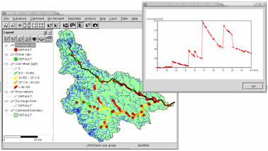
GREAT-ER is a simulation system for modeling the environmental fate of substances in rivers with a GIS based user interface. The development of GREAT-ER II is performed under the CEFIC Long Range Research Initiative (LRI) Environmental Exposure Programme. The tender has been awarded to the consortium of Intevation GmbH and TechniData AG, Markdorf (Germany) in late 2001.
The project ran from April 2002 to September 2003. Intevation is responsible for the model and analysis system with two user interfaces (desktop and web-based) as well as data preprocessing.
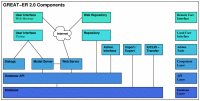
Client-Server Architecture:
Massively georeferenced modelling requires high computing performance. The overall system architecture considers distributing the workload on dedicated systems: E.g. User Workstation, Database Server, Computing Server(s). If needed all these can run on a single computer.
Independent Desktop User Interface:
Intevation has launched the Free Software Project Thuban to realise the platform independent basis for the desktop application.
Web based User Interface:
A user interface implemented in a web based application framework provides access on GREAT-ER II without any further installation required.
Flexible Model System:
The GREAT-ER model concept has proven its relevance and applicability over the last years. GREAT-ER II now realises a framework to exchange the current models and to extend GREAT-ER to new compartments in the future.News
-
Archive

- PostGIS
- OpenLayers
- MapProxy
- FOSSGIS